
Read about the Memorial Drive trees and important sites of remembrance in Hillhurst Sunnyside this November.

BUILDING COMMUNITY ONE STREET AT A TIME: Hillhurst Sunnyside neighbours gather at the pedestrian gates of historic 10A, 11, 11A and 12 Streets (with bonus Gladstone Road) at a recent community photo shoot. Photo collage by Stephanie Corbett
Written by Lisa Chong: this article appeared in the September 2019 issue of the Hillhurst Sunnyside Voice
Walking along the north side of Kensington Road, reminders of our neighbourhood’s historic street names are posted on the splendid wrought iron pedestrian gates into the residential areas of our 100+ year old community: 10A St was Norfolk Road; 11th St was Beverley Street; 11A St was Preston Street; and 12th St was Oxford Street. The street gates were designed by resident and visual artist, Pamma FitzGerald in ~1992 and appears on the September 2019 cover of the Hillhurst Sunnyside Voice newsletter (above).
Prior to European settlement, this area was home to the people of the traditional Treaty 7 nations, the Piikani, Siksika, Kainai, Iyarhe Nakoda and Tsuut’ina. Gladstone Road / 4 Ave – which crosses our community diagonally (SW to NE) from 14th Street to 10th Street – was part of an indigenous trail, which explains why this roadway breaks from the gridiron layout of Calgary’s inner city communities.
Street names in Calgary’s early days often reflected the heritage of the landowners. Author, Harry Sanders describes that Hillhurst streets were given Anglo-Saxon names to attract British residents in the same way that Bridgeland streets were given Italian names in the predominantly Italian neighbourhood.
10th Street was formerly Morleyville Road which led to the Methodist Mission in Morley; the very short 3rd Ave in Hillhurst was known as Cornwall Avenue, while 13th St was Richmond Street. As we move west to what was historically Upper Hillhurst, there is a note indicating “Scattered Wooden Dwellings Beyond” in neat printed writing on the old fire insurance maps; indeed, the area was home to a few small-scale agricultural and textile facilities. 14th St was known as Strathcona Street; 15th St was Imperial Avenue and 16th St was Nelson Street. 1st Ave (between 16th & 18th Streets) was Alexandra Street.

Aerial map 1924-26: City of Calgary
7th Ave, adjacent to the St. Barnabas Anglican Church was fittingly, Church Ave, while 5th Ave in Hillhurst was originally Victoria Avenue. The soon-to-be-built “Victoria on 5th” apartment redevelopment between 10th St and 11th St takes its name from the historic street name, which was given in honour of Queen Victoria (1818-1901).
Riley Park: Ezra Hounsfield Riley and his family were prominent homesteaders and sold the land (now Hillhurst) to the City of Calgary between 1904-1910. They resided on Buckingham Ave (8th Ave) where the Agape Hospice stands today. The adjacent 8.23-hectare Riley Park was donated by the Riley family to the citizens of Calgary as a public park.

Salvation Army Sunset Lodge, formerly Ezra Riley home, then Salvation Army Rescue Home, 1302 8th Avenue NW: Allison Jackson, 1965
Sunnyside was a predominantly a Scottish homesteading settlement in the late 1800s and was called New Edinborough. Sunnyside was developed further in the early 1900s by the CPR as the community grew. Numbered streets started perpendicular to the Bow River and westward from Centre Street. 9A St next to the train tracks was once Merchiston Avenue, a name that reflects Sunnyside’s Scottish-Edinburgh origins.
New Edinborough Park located in the heart of Sunnyside – continues to be the community gathering place for the annual volunteer-led park party celebrating community spirit after the 2013 flood. It is also where Calgary’s annual, city-wide Neighbour Day got its start!
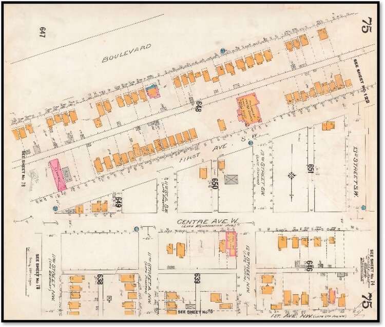
Calgary 1911-14 Fire Insurance Map: University of Calgary
Kensington Road/Centre Avenue: Calgary historian, Alan Zakrison says that Kensington Road and many of the streets in Hillhurst were named by the primarily English settlers. After some back and forth between the City and communities in switching between numbered streets and named streets, the City of Calgary decided that the dividing line between North Calgary and South Calgary would be Kensington Avenue (renamed to Centre Avenue) north of the Bow River.
Because the Centre Ave dividing line was causing a great deal of confusion, the north/south boundary was changed in 1925 to follow the north and south banks of the Bow River. Centre Ave NE still exists in Bridgeland to this day. Centre Ave NW was renamed back to Kensington Ave (later Kensington Road) and the streets to the south of Kensington continue to this day with historic names such as Westmount Road (1st St SW), Bowness Road (2nd St SW) and Broadview Road (3rd St SW) in the neighbourhoods of Westmount (west and between 14th St and Crowchild Trail) and Broadview (east and between 14th St and 10th St).

Calgary 1912 Map: Calgary Public Library
Memorial Drive NW: Memorial Drive was known as Broadview Boulevard prior to 1911, The Boulevard from 1911-1919, and Westmount Boulevard (west of 10th St) from 1919-1965. Memorial Drive is also the north/south boundary east of Deerfoot Trail today.
Yes, there is a Bowness Road in Hillhurst Sunnyside! Residents in the area recount that Bowness Road was laid out with extra width because it was intended to host the streetcar route leading to the town of Bowness (annexed to the city of Calgary in 1964). The 1945 Municipal Railway Map shows the route running along Kensington Road and onto Bowness Road instead.
Today, Hillhurst’s Bowness Rd hosts one of three lilac medians in Hillhurst, planted by the City of Calgary’s third Parks & Cemetery superintendent, William Reader between 1929-32. The lilac medians on 6th Ave, 11A St and Bowness Rd were planted during the City Beautiful Movement, which was a deliberate effort to construct tree-lined boulevards and medians with formal plantings and to beautify city streets and contribute to citizen well-being. The three lilac streetscapes were added to the City’s Inventory of Historic Resources in 2011.
Bowness Rd continued under its moniker as it made its way east across 14th Street. Some time ago, the eastern portion of Bowness Rd was renamed to Kensington Crescent between 11A and 11th Streets. In the 1990s, the developer of the Providence Kensington condos used this precedent and obtained signatures going door-to-door and through a plebiscite, the western portion of Bowness Rd between 13th St and 11A St became Kensington Close. This change was intended to reflect a more prestigious street address for the building.
Do you have any stories about your street? Contact lisa.c@hsca.ca and share your story with the HSCA Heritage Subcommittee and we would be happy to include these in a future article. You can also view Margaret Tanko’s Hillhurst Sunnyside Remembers (1978) book located on our website at: www.hsca.ca.
Resources/Sources:
Alan Zakrison, Calgary historian and researcher, Old Sidewalk Stamps
Calgary Fire Insurance Maps (1911-14)
Calgary Municipal Railway (January 22, 1945)
Calgary Public Library: Historic Maps of Calgary and Alberta
Harry Sanders, Historic Walks of Calgary (2005)
Lorna Cordeiro, Pamma Fitzgerald, Patti Dawkins & Robin Lee, Hillhurst Sunnyside residents